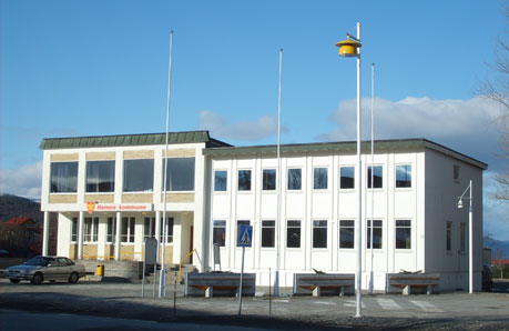
Hemne is a former municipality in Trøndelag county, Norway. The municipality existed from 1838 until its dissolution in 2020 when it was incorporated into Heim Municipality. It was part of the Fosen region. The administrative centre of the municipality was the village of Kyrksæterøra. Other villages included Heim, Hellandsjøen, Holla, and Vinjeøra. The European route E39 highway passed through the southern part of the municipality.
Prior to its dissolution in 2020, the 670-square-kilometre (260 sq mi) municipality is the 168th largest by area out of the 422 municipalities in Norway. Hemne Municipality was the 225th most populous municipality in Norway with a population of 4,228. The municipality's population density was 6.3 inhabitants per square kilometre (16/sq mi) and its population has increased by 0.07% over the previous 10-year period.
General information
The parish of Hemne was established as a municipality on 1 January 1838 (see formannskapsdistrikt law). On 1 January 1911, the northern district of the municipality (population: 1,533) was separated from Hemne to form the new Heim Municipality. This left Hemne Municipality with 3,425 residents. On 1 July 1924, Hemne Municipality was further divided into three: with the eastern district (population: 776) became Snillfjord Municipality, the southern district (population: 716) became Vinje Municipality, and the rest remained as a much smaller Hemne Municipality (population: 2,030).
During the 1960s, there were many municipal mergers across Norway due to the work of the Schei Committee. On 1 January 1964, Hemne Municipality was enlarged when all of Vinje Municipality (population: 576) and the parts of Heim Municipality located west of the Hemnfjorden (population: 711) were both merged into Hemne Municipality.
On 1 January 2008, the Fossdalen farm (population: 4) was transferred from the neighboring Rindal Municipality (in Møre og Romsdal county) to Hemne Municipality (in Sør-Trøndelag county).
On 1 January 2018, Hemne Municipality switched from the old Sør-Trøndelag county to the new Trøndelag county.
On 1 January 2020, Hemne Municipality was dissolved. Its lands were merged with the Ytre Snillfjord area in the neighboring Snillfjord Municipality and all of the neighboring Halsa Municipality to form the new Heim Municipality (resurrecting an old name for the area).
Name
The municipality (originally the parish) is named after the Hemnfjorden (Old Norse: Hefn) since flowed through the area. The name is derived from the word hǫfn which means "port" or "haven" (referring to the good port of Hemnskjel). Historically, the name of the municipality was spelled Hevne. On 3 November 1917, a royal resolution changed the spelling of the name of the municipality to Hemne.
Coat of arms
The coat of arms was granted on 14 June 1991 and it was in use until 1 January 2020 when the municipality was dissolved. The official blazon is "Gules, five hazelnuts in annulo stems to center conjoined Or" (Norwegian: I rødt fem gull hasselnøtter forent i rosett). This means the arms have a red field (background) and the charge is five hazelnuts in a circular arrangement with their stems connected in the centre. The hazelnet design has a tincture of Or which means it is commonly colored yellow, but if it is made out of metal, then gold is used. The design symbolizes the relatively large hazel forests in the municipality, which was historically important to the local economy. The arms were designed by Einar H. Skjervold.
Churches
The Church of Norway had three parishes (sokn) within Hemne Municipality. It is part of the Orkdal prosti (deanery) within the Diocese of Nidaros.
Geography
Hemne Municipality was bordered on the east by Snillfjord Municipality and Orkdal Municipality, on the south by Rindal Municipality (in Trøndelag county) and Surnadal Municipality (in Møre og Romsdal county), and on the west by Aure Municipality and Halsa Municipality (both in Møre og Romsdal county). To the north, across the waters of the Trondheimsleia was Hitra Municipality.
The Hemnfjorden formed the border between Hemne Municipality and Snillfjord Municipality. The Vinjefjorden was located on the southwestern side of the municipality and the lake Vasslivatnet was in the southeast. In the south near the village of Vinjeøra, there are several hiking trails to mountain lodges such as Sollia. The highest point in the municipality was the 1,039.96-metre (3,411.9 ft) tall mountain Ruten.
The Grønkjølen Nature Reserve was located in the extreme south of the municipality.
Government
While it existed, Hemne Municipality was responsible for primary education (through 10th grade), outpatient health services, senior citizen services, welfare and other social services, zoning, economic development, and municipal roads and utilities. The municipality was governed by a municipal council of directly elected representatives. The mayor was indirectly elected by a vote of the municipal council. The municipality was under the jurisdiction of the Sør-Trøndelag District Court and the Frostating Court of Appeal.
Municipal council
The municipal council (Kommunestyre) of Hemne is made up of 23 representatives that are elected to four year terms. The tables below show the historical composition of the council by political party.
Mayors
The mayor (Norwegian: ordfører) of Hemne was the political leader of the municipality and the chairperson of the municipal council. Here is a list of people who held this position:
Notable people
- Arne Heimsjø (1915–1989), a Norwegian military officer
See also
- List of former municipalities of Norway
References